Current Wildland Fire Info For Those Who Live in Fire-prone Areas
Whether you live in an area that frequently has wildfires, are planning a summer trip, or want to give your loved ones ways to keep up with you when you’re fighting fire, here’s a list of resources.
For the most up to date info on an emerging wildfire that’s threatening your home or safety, check your local county, national forest, sheriff’s department, etc on social media (Twitter/ Instagram/ Facebook/ TikTok) and there’s usually frequent updates as well as info on how to sign up for evacuation alerts. Please try this before you call 911 or your local forest. Being overwhelmed by individual phone calls slows them down when they are trying to get and disperse information that is easily available online!
Other tips: check accounts like @inciweb and @thehotshotwakeup and search hashtags of the fire name on twitter and instagram. That’s how I’ve found info/ pics that’re not yet posted on official channels.
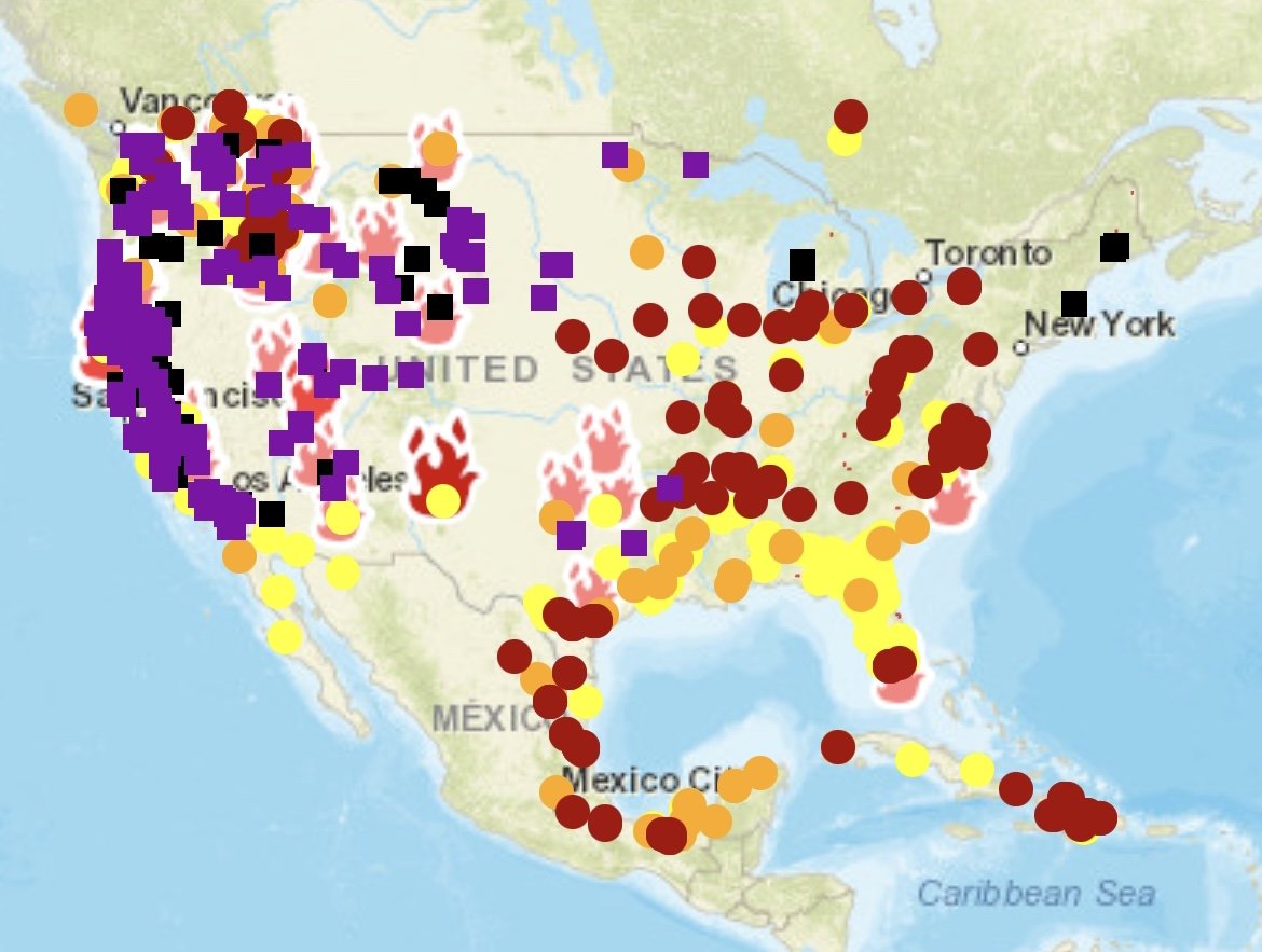
Source: maps.nwcg.gov
maps/ specific fire information
NIFC Fire Information (nifc.gov/fire-information) This is a one stop shop of national fire information, including maps, news, reports, statistics and easy to read infographics on current fire levels.
National Fire Situational Awareness (maps.nwcg.gov) This is my favorite interactive site to look at new wildfires. It shows small and large fires, is updated throughout the day, and has a color system/heat level associated with them so you can see if they are still ripping or not (For example red dots indicate a very active part of the fire while yellow dots are on the least active parts). It will show perimeters on large fires once they get established. If you click on a fire symbol it will bring up more info on the left side. There, if you click on the same symbol again next to the fire name it will bring up fire size, containment, when it was last updated and more.
InciWeb the Incident Information System (nwcg.gov) This is another great interactive site that’s very similar to the one above, but it has way more information on each wildfire. I find that it’s not updated as quickly for emerging incidents as the maps.nwcg.gov site, but it also shows fire perimeters once a fire gets established. It’s best to get in depth information for large active fires on tactics and strategies, updates, road and trail closures, photos and videos of the fire, maps and contact information including phone numbers if you have questions about a specific wildfire.
NYT Interactive Fire Tracker The map includes active and recent fires and air quality and smoke forecasts in a super clean, easy to navigate interactive map that gives the highlights of major large fires nationally. Areas marked in red indicate where active burning was detected within 24 hours.
The Geographic Area Coordinating Center and National Fire Center Portal (gacc.nifc.gov) gives you quick links to every geographic area and national info. From there you can nerd out on each area’s fire activity, large fires, fire potential forecasts, fire danger levels and more.
HOW TO BE PREPARED WHILE RECREATING
Wildfire Safety Tips for Outdoor Recreation (rei.com) This article gives practical advice on how to plan an outdoor trip during wildfire season, resources to check before you go, gear to pack in case you encounter a fire, what to do if you encounter wildfire smoke or flames, how to report a wildfire and campfire safety tips.
How to Plan Summer Adventures in the Era of the Megafire and How to Plan a Hike During Wildfire Season (outsideonline.com) These articles include info on mapping apps and websites that show current fire info, smoke monitoring tools, route planning, gear to bring, and what to do if you encounter a wildfire threat on the trail.
Smoke forecasts
AirNow.gov A great interactive air quality and forecasting site for smoke. There is a current wildfire map of the US and the Fire and Smoke map specifically gives you FPM (Fine Particulate Matter) conditions.
Airquality.weather.gov NOAA is another great site for smoke and air quality information. They have tons of other maps showing vertical smoke, current fires, and resources for how to decipher a fire warning from a fire watch during an evacuation along with other wildfire preparedness and safety info.